PGC News & Announcements: March 15, 2019
Missed out on the newsletter via email? Sign up here!
Claire Porter Wins NOAA David Johnson Award

The PGC is proud to announce Claire Porter is the recipient of the NOAA David Johnson Award for Outstanding Innovative Use of Earth Observation Satellite Data for her work contributing to the production of ArcticDEM and REMA! Her achievements pave the way for the continuous production of global digital elevation models. Way to go, Claire!
She will receive the award at the 62nd Annual Dr. Robert H. Goddard Memorial Dinner this spring in Washington, DC. Each year the National Space Club and Foundation recognizes awards selected by a panel of experts from across the aerospace and defence industry, government and academia that capture “inspiring work of individuals across the United States.”
For more information about the David Johnson award and a list of its previous award recipients.
Check out the list of this year’s National Space Club and Foundation award recipients here as well as the official press release.
Watch the video of last year’s memorial dinner keynote speaker on YouTube.
REMA Publication in The Cryosphere

Howat, I. M., Porter, C., Smith, B. E., Noh, M.-J., and Morin, P.: The Reference Elevation Model of Antarctica, The Cryosphere, 13, 665-674, https://doi.org/10.5194/tc-13-665-2019, 2019.
PGC Greenland + Alaska Imagery Mosaic Updates
We generated two significant regional updates to our Arctic 50 cm imagery mosaic available to Users via our web-based mapping application. PGC’s Arctic, Antarctic, and World imagery viewers provide quick access to hundreds of terabytes of orthorectified commercial high-resolution satellite imagery, mostly of WorldView 1, 2, and 3 sensors. More information about our viewers can be found on our website.
- Both Greenland and Alaska 50 cm panchromatic commercial mosaics have been updated in their entirety.
- The mosaics were created with priority given to the newest (current up to 2018), low cloud cover imagery collected in the summer, though they do utilize imagery from DigitalGlobe’s entire temporal range.
- The new mosaics address collection gaps found in the previous mosaics, particularly in Greenland’s interior and the Aleutian Islands in Alaska.
Access to secured and licensed data layers in PGC’s Imagery Viewers are restricted to current federally-funded polar researchers, federal employees, or subcontractors. New Users can request an account here.
New Login System on PGC Website

At the beginning of the year, PGC launched its new authentication system on our website. This is our first step towards a more automated self-service model for data delivery. We have integrated the many different accounts with PGC such as Imagery Viewer apps, FTP download, website login, etc., along with updating our web services.
Users with verified current federal funding gain access to the high resolution imagery viewer applications, web services, as well as the public content on our website. Users that do not meet our requirements for access to restricted content have access to online public content only.
To create a new account, visit https://users.pgc.umn.edu and click the Request an Account button. PGC staff will review submissions and respond with account confirmations.
To access our updated web services from a desktop client:
- For public layers: https://overlord.pgc.umn.edu/arcgis (no authentication needed)
- For restricted and public layers: https://secure.overlord.pgc.umn.edu/arcgis
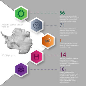
Antarctic On-Ice Support Recap

Our 11th Antarctic on-ice support season has come to an end. It was another successful deployment for the PGC team, despite an unexpected scheduling conflict at the beginning of the season.
Thank you to our Users for your understanding and cooperation of our early 2018-19 season absence!
We are pleased to continually provide science and logistics support from McMurdo Station each austral summer, even if that means eating fewer freshies for a couple of months.
Already looking forward to the next season!
