Message to our Polar Community
Dear Polar Science Community,
As we continue to navigate the challenges of conducting research in Earth’s most extreme and rapidly changing environments while navigating today’s political climate, your dedication and resilience remain an inspiration. The polar regions are at the forefront of global climate change, and the work you do—whether in the field, in laboratories, or through remote sensing—is critical to understanding these complex systems and their global implications.
At PGC, we recognize the obstacles you face in your research. That is why we remain committed to providing you with the highest quality geospatial data, imagery, and analytical tools to support your work. Our resources and tools are designed to make accessing and utilizing geospatial data and imagery more efficient, empowering you to focus on groundbreaking discoveries. We are also dedicated to expanding access to these resources, ensuring that more researchers, both established and upcoming, can contribute to polar science. We understand that your research is vital not only for understanding the polar regions but also for informing policies and strategies that will shape the future of our planet.
Whether you need data support, technical assistance, or collaboration opportunities, PGC is here to assist you. We are proud to be part of this remarkable community, and we will continue to work alongside you to ensure that the best tools and resources are available to advance your science.
Thank you for your dedication, perseverance, and contributions to polar research. Your work matters, and we stand with you every step of the way.
Warm regards,
Cole Kelleher,
PGC User Services Manager
PGC News & Updates
New Access to PGC DEMs: Dynamic STAC API
PGC is pleased to announce a new way to access our public high-resolution polar elevation datasets: the PGC Dynamic STAC API! Driven by our user community feedback, this enhancement expands our commitment to providing more diverse, flexible, and efficient access to ArcticDEM and REMA while streamlining workflows.
Building on our existing static STAC access, this new method allows users to:
- Query DEM collections dynamically based on spatial and temporal parameters
- Integrate directly into python workflows and GIS application
- Retrieve data from the cloud without downloading individual files
Learn more: PGC STAC Access Guide
Get Started: PGC Code Tutorials
Questions? Contact pgc-

Historic Antarctic Maps Now Publicly Available in PGC Map Catalog
 PGC recently collaborated with the American Geographical Society (AGS) to publicly release a collection of Antarctic map folios, previously restricted due to copyright license. AGS has a rich history of advancing geographic knowledge and their extensive cartographic collection played a key role in major historical events. From the late 19th to the mid-20th century, AGS led national efforts in geographic research and mapping.
This release of Antarctic map folios offers researchers and polar science enthusiasts an opportunity to engage with a historic and invaluable cartographic resource. While AGS retains the copyright, they have agreed to allow distribution of the maps for academic use. For inquiries about the full scope of the license, please contact AGS directly. Check out the AGS Antarctic collection in the link below.
Access to AGS Maps in PGC Catalog
Introducing New Layer in PGC Imagery Viewer:
McMurdo Pansharpened Multispectral Imagery Mosaic
PGC’s Imagery Viewer is a web-based mapping app, featuring panchromatic (grayscale) and multispectral (RGB color) polar imagery mosaics. We are excited to introduce a new mosaic type: 50cm Pansharpened Multispectral Imagery Mosaic, with the first installment covering Ross Island and the McMurdo Dry Valleys region of Antarctica. The RGB imagery, typically 2m in resolution, has been combined with 50cm panchromatic data for the best of both worlds.
The Imagery Viewer app is a critical tool for users needing quick access to hundreds of terabytes of orthorectified satellite imagery. A significant effort goes into keeping mosaics updated in order to be useful for varying cases. Check out the new layer at https://viewers.apps.pgc.
Here is a highlight of the new McM Pansharpened layer:
- 18 tiles (100km x 100km each)
- 158,000 sq km of land area
- 1,775 individual imagery scenes
- 74% of imagery from the last three years
Access to secured and licensed data layers in PGC’s Imagery Viewers are restricted to current federally-funded polar researchers, federal employees, or subcontractors. New users can request an account here.
PGC verifies all funding sources after you submit an account request.


New Members Join PGC Advisory Committee
We are delighted to welcome three new members to our Science and Operations Advisory Committee (SOAC):
- Hannah Bradley – University of Virginia Arctic Research Center
- Curt LaBombard – NSF Ice Core Facility
- Dr. Latha Baskaran – NASA Jet Propulsion Laboratory
As the research and funding landscape changes, PGC is leaning in on SOAC’s guidance to help navigate this critical time. We are grateful for the committee’s ongoing partnership and look forward to reaching new milestones together.
To learn more about all of our committee members, visit the bottom of the About page on our website.


Thanks to everyone who submitted nominations. It is an honor to receive many interested and qualified candidates.
Conference Connections
PGC at ASSW25
 We are excited PGC team members are participating in the Arctic Science Summit Week (ASSW) through their talks and posters, see below for details. We look forward to engaging with the community!
![]() : 20–28 March 2025
: 20–28 March 2025
![]() : Boulder, Colorado, USA, hosted at the University of Colorado Boulder
: Boulder, Colorado, USA, hosted at the University of Colorado Boulder
![]() : https://assw.info/
: https://assw.info/
Talk:
Expanding Arctic Research: The Role of ArcticDEM in Data Accessibility
Presenter: Cathleen Torres Parisian
Session: 8.4 – Making Arctic Science Equitable and Accessible to All Through Open Science
Date: Tuesday, March 25, 2025
Posters:
Dynamic STAC API for Searching and Retrieving ArcticDEM Data
Presenter: Jesse Bakker
FRIDGE: Empowering Polar Research with Dynamic Access to High-Resolution Satellite Imagery and Digital Elevation Models
Presenter: Cole Kelleher
Date: Wednesday, March 26, 2025
Time: Poster exhibit from 10:30 AM – 6 PM; Poster reception from 6-8 PM
Geoscience Alliance 6 Conference
 PGC is excited to announce our participation in the upcoming Geoscience Alliance conference for the second time. This year’s theme, “Geoscience and Environmental Justice in Indigenous Communities,” aligns with our commitment to being part of the solution in addressing the benefits, burdens, and power dynamics impacting Indigenous communities. We aim to enhance the use, understanding, and application of geospatial data to empower underrepresented populations and address environmental and climate impacts.
![]() : 24-26 April 2025
: 24-26 April 2025
![]() : Duke University, Durham, NC
: Duke University, Durham, NC
![]() : https://geosciencealliance.
: https://geosciencealliance.
PGC Impact Story
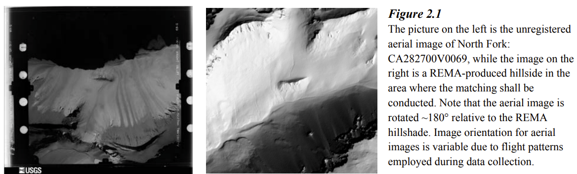
Support Vignette: “Computer Vision for Airborne Imaging of Antarctica: Creating a 75-year Record of Surface Change”
Last summer, PGC piloted an internship opportunity with undergraduate Sani Deshmukh of California Institute of Technology. Deshmukh’s work explored the effectiveness of contemporary computer vision algorithms in aligning high-resolution airborne imagery with modern elevation data. By testing various feature-matching techniques, Deshmukh’s research aimed to enhance the accuracy of time-series image registration, to help improve the ability to track surface changes over time.
With support from the PGC—including staff mentorship, technical guidance, and access to Antarctic aerial imagery and REMA, PGC’s high-resolution digital elevation models (DEMs) —the project successfully tested feature-matching algorithms to align the aerials with modern DEMs. While the approach showed promising results, Deshmukh concluded the work was computationally intensive, highlighting the need for more efficient matching techniques. Deshmukh outlined future improvements could focus on optimizing processing time, refining hillshade detection methods, and incorporating other AI approaches such as neural networks, to enhance accuracy and scalability.