
In this guide
FRIDGE User Guide
Last Updated: March 18, 2025

Overview
The FRIDGE application allows users to quickly access PGC elevation and satellite imagery products of polar regions with detailed geographic information. It provides tools to view, download, and order high-resolution satellite data products. This guide walks through the core features and how to use the application effectively.
Quick Links
Table of Contents
background
Account registration
license and usage
public data
commercial satellite imagery
common questions
feedback
contact
Background
The Polar Geospatial Center maintains a multi petabyte-scale archive of digital elevation models (DEM) and commercial satellite imagery covering the Earth’s polar regions. Querying and accessing data from such a large archive presents many opportunities. PGC’s Federal Research Imagery and DEM Geospatial Explorer (FRIDGE) was developed to provide the U.S. funded polar science and logistics community streamlined and dynamic access to this extensive imagery archive through a web-based application with standardized imagery product options. FRIDGE also provides open access to DEMs produced through the ArcticDEM and Reference Elevation Model of Antarctica (REMA) projects.
FRIDGE has two primary interfaces:
- Public Data which facilitates open access to the ArcticDEM and REMA elevation data products with no authentication required.
- Commercial Satellite Imagery which facilitates secure access for U.S. funded polar researchers and logistics personnel to Maxar commercial satellite imagery covering the polar regions in accordance with the Electro-Optical Commercial Layer (EOCL) license. Authentication and user permissions are managed by PGC User Accounts, allowing access to many other PGC applications.
Account Registration
Access to the Public Data (availabe Polar Digital Elevation Models) does not require a PGC account login.
Access to the secured and licensed Commercial Satellite Imagery requires a PGC account login and is limited to polar federally-funded researchers with current awards, federal employees, or subcontractors. Primary funding comes from, but is not limited to, the National Science Foundation (NSF) Office of Polar Programs. Members of the DoD/IC and Antarctic/Arctic support personnel may also request access.
The link below is for new users to request a new account. The PGC will verify your funding source after you submit a request for an account.
License & Usage
By using PGC products and services, including accessing data via FRIDGE, users agree to:
- Acknowledge PGC and its sponsorship by the National Science Foundation (NSF) in all publications, web pages, and media interviews.
- Properly attribute the original source of any third-party data supplied by PGC.
Acknowledging PGC’s support is essential for providing feedback and measuring its impact within the scientific community.
For Data specific guidelines:
Public Data
When using open data or resources from the FRIDGE application, proper acknowledgment and citation are required to give credit to the authors and providers, maintain academic integrity, and support reproducibility of research. Visit the links below for guidance:
Commercial Satellite Imagery
When using licensed data or resources from the FRIDGE application, proper acknowledgment, citation, and publication approval are required to comply with the licensing agreement, give credit to the authors and providers, maintain academic integrity, and support PGC. Visit the links below for guidance:
Public Data
Polar Digital Elevation Models
FRIDGE Public Data currently consists of polar digital elevation models (DEMs). 2-meter resolution DEMs produced under the ArcticDEM and REMA projects are freely available through FRIDGE in two product types, strips and mosaics. All DEMs may be previewed as hillshades within FRIDGE and downloaded directly from the interface.
1. Strips vs. Mosaics
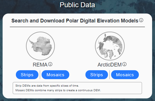 PGC elevation strips are narrow slices of elevation data corresponding to the overlapping area, specific time, and dates of the input pair of stereoscopic images from which they were derived. DEM strips are valuable for temporal and time-sensitive analyses due to their specific timestamps but do not undergo visual inspection prior to release. DEM strips can be queried temporally and/or geographically.
PGC elevation mosaics combine many of the strips into one seamless tile, giving a complete view of the terrain. DEM mosaics are valuable for their comprehensive coverage and visualizations. Mosaic tile DEMs can only be queried geographically.
Think of strips as individual pieces, and mosaics as the full picture.
2. User Interface Overview
Upon launching a chosen regional product of the Polar Digital Elevation Models (REMA/ArcticDEM and Strips/Mosaics), users encounter a map-based interface with several essential components (shown below is the interface for REMA Strips):
Main Screen Layout
| # | Item | Description |
|---|---|---|
| 1 | Settings | Visit FRIDGE landing page to change datasets and access feedback form. |
| 2 | Navigation Panel | Interact with the map window with zoom, trash/clear, and selection tools. Define an area of interest (AOI) by drawing a rectangle, polygon, radius, or location point using the map viewport. Save AOIs for future use cases. |
| 3 | Map Display Options | View placename labels and DEM data scene previews. |
| 4 | Query Panel (strips only) | Query tools to manage various metadata parameters: time, collection method (in-track, cross-track), and percent valid data. See *note* below and PGC DEM guide for more information. |
| 5 | Scale Bar | Align the measurement with the bar to estimate the real-world distance (kilometers or miles). |
| 6 | Data Sources | Data providers of foundational basemap and geospatial layers. |
| 7 | Coordinates | View the map coordinates in decimal degrees at your cursor location. Use the PGC coordinate converter app to update your inputs to the correct format. |
| 8 | Search Location | Find specific locations or features by placenames or decimal degree coordinates. |
| 9 | Map Geometry Cart | Add selected scenes to the cart to export geometry files in shapefile or GEOJson formats that can be used in a geographic information system. |
| 10 | Map Window | View digital elevation models of the polar region selected in the central display. |
| 11 | Landing Page | Visit FRIDGE landing page. |
*Note about #4 QUERY Panel (Strips only)
The query panel allows users to apply metadata parameters to better narrow selections.
- Date selection: Choose between Set Time Range or Specify Months/Years to constrict your search based on temporal needs.
- Cross-Track Filter: Check the box to exclude cross-track DEMs. This tool allows users to restrict or expand their DEM search based on the stereoscopic imagery collection mode. A stereoscopic pair can also be acquired in cross-track stereo mode when the satellite completes at least one orbit between the two image collections. However, in-track stereo is more accurate because less will have changed in the target location between the two shots.
- Percent Valid Data: Filter the strip DEM dataset based on the data quality using the slide bar of percent valid data. In the context of strip DEM metadata fields, “valid” means pixels that are not identified as potentially erroneous data in the strip bitmask raster.
Find more information about percent valid data in the PGC DEM Products Guide: Metadata
3. Downloading Data
FRIDGE is one of many ways to access PGC’s publicly available ArcticDEM and REMA elevation products (see link below). Elevation data is accessed or downloaded one file at a time rather than in large batches, commonly used when users need specific, targeted datasets. If you require larger datasets, please see our PGC DEM guide for bulk download options (see link below), reach out to your PGC Point of Contact or email pgc-support@umn.edu.
Find more information about other access points, including bulk download in the PGC DEM Products Guide: Search, Discovery and Download
3.1 STAC Item
All publicly-available DEM data from PGC are also hosted in an open AWS bucket and indexed with a STAC catalog. DEM data assets can be identified using the DEM STAC items and downloaded or used directly in the cloud. Several different products of the selected dataset are available for direct download including hillshades, masked datasets, metadata, and more.
3.2 DIRECT Download
Direct download links simplify the process of acquiring datasets with a one-click option for users to download individual elevation files. All direct downloaded files are packaged as a tarball (.tar.gz) file, a collection of files wrapped up in one single file for easy storage. In a Windows system, use a file archiver application, such as 7-zip, to extract TAR.GZ files. Alternatively, downloaded files can be extracted through command line.
Find more information about the file structures in the PGC DEM Products Guide: Metadata
Commercial Satellite Imagery
Maxar Commercial Satellite Imagery
PGC provides access to its archive of Maxar high-resolution commercial satellite imagery of the polar regions through FRIDGE, available through the EOCL license, an agreement between NRO and Maxar Technologies, to users with a registered PGC User Account and verified NSF Office of Polar Programs (OPP) award information. The imagery archive contains imagery at its native resolution from 6 sensors (IKONOS, Quickbird, GeoEye-1, WorldView-1, WorldView-2, WorldView-3) spanning from the early 2000s to the present, with new acquisitions reguarly added.
Users can dynamically query the imagery within FRIDGE by geographic location, acquisition date, sensor type, cloud cover, band combinations, illumination, and look angles. The interface also allows users to preview all available imagery. Ordered raw or processed products are delivered to users’ private FTP folders, accessible with a PGC account, with notifications sent via email.
1. Award & Collection Selections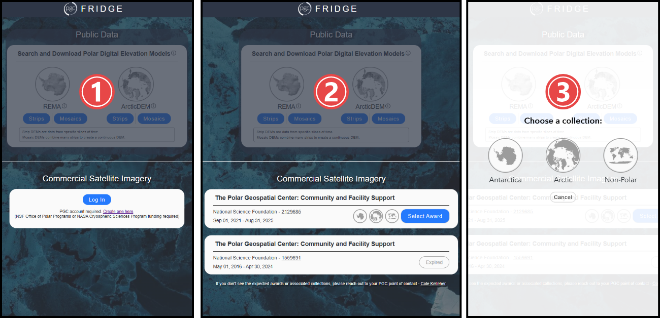
- Users must first register and log in using their PGC User Account to access any Commercial Satellite Imagery, as required by EOCL licensing restrictions.
- & 3. Once logged in, users must select the verified NSF award associated with their data request. If selected award spans multiple geographic regions, users must select a corresponding collection (Antarctica, Arctic, Non-Polar). This important step ensures compliance with the EOCL license, which permits researchers to use the data exclusively for their federal award during its active period. All data requests must align with the selected award to maintain licensing compliance.
Find more information about licensing restrictions in the EOCL FAQ.
2. User Interface Overview
Upon launching the chosen regional collection of commercial satellite imagery, users encounter a map-based interface with several essential components (shown below is the interface for Arctic imagery):
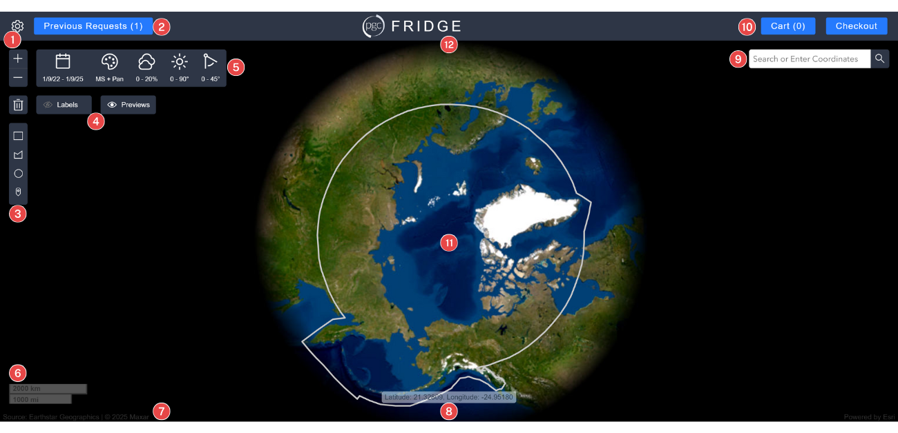
Main Screen Layout
| # | Item | Description |
|---|---|---|
| 1 | Settings | Visit FRIDGE landing page to change datasets and access feedback form. |
| 2 | Previous Requests | History of previous requests including deliverable IDs, footprint downloads, and lists of files. |
| 3 | Navigation Panel | Interact with the map window with zoom, trash/clear, and selection tools. Define an area of interest (AOI) by drawing a rectangle, polygon, radius, or location point using the map viewport. Save AOIs for future use cases. |
| 4 | Map Display Options | View placename labels and imagery scene previews. |
| 5 | Query Panel | Query tools to manage various metadata parameters: time, band selection (multispectral, panchromatic), cloud cover percent, sun elevation angle, off-nadir angle. See *note* below for more information. |
| 6 | Scale Bar | Align the measurement with the bar to estimate the real-world distance (kilometers or miles). |
| 7 | Data Sources | Data providers of foundational basemap and geospatial layers. |
| 8 | Coordinates | View the map coordinates in decimal degrees at your cursor location. Use the PGC coordinate converter app to update your inputs to the correct format. |
| 9 | Search Location | Find specific locations or features by placenames or decimal degree coordinates. |
| 10 | Cart and Checkout | Add selected scenes to the cart to review prior to ordering the specific product formats in checkout. Request the imagery product format suited for the intended application. Reference the PGC image processing options and processing decision table to determine the optimal format per use case. Please note all selected scenes in cart will be processed according to the requested product specifications. |
| 11 | Map Window | View imagery scenes of the polar region selected in the central display. |
| 12 | Landing Page | Visit FRIDGE landing page. |
3. Querying Data
3.1 About Area of interest (aoi)
Before users can perform other functions, such as querying or previewing data, users must define an Area of Interest (AOI). Users can define an AOI in serveral ways including: drawing a rectangle, polygon, radius, or location point using the map viewport.
After users create an AOI, there is an option to ![]() Save AOIs and name them for future use (limited to 10 total). Saved AOIs can be downloaded as a shapefile, GEOJson, and GeoPackage.
Save AOIs and name them for future use (limited to 10 total). Saved AOIs can be downloaded as a shapefile, GEOJson, and GeoPackage.
3.2 About Query panel
The query panel allows users to apply metadata parameters to better narrow selections.
 Date selection: Choose between Set Time Range or Specify Months/Years to constrict your search based on temporal needs.
 Band selection:Check the Multispectral box to include imagery with multiple layers of light (e.g. visible, infrared) and/or check the Panchromatic box to include high-resolution black-and-white imagery that shows fine details but lacks color information.
 Cloud Cover Percent:Filter the imagery based on the cloud coverage using the slide bar of percent coverage. Percentages are developed by the satellite company algorithm and apply to the entire image scene. Using the filter may exclude scenes with good coverage over an area but are cloudy elsewhere. Snow may be mistaken as clouds.
 Sun Elevation Angle: The angle between the sun and the horizon, indicating how high the sun is in the sky when the image is collected (0-90°).
 Off-Nadir Angle: The direction pointing directly below a particular location or sensor, indicating the angle at which an image is collected (0-60°).
Find more information in the Introduction to Satellite Imagery guide
4. Ordering Data
4.1 About cart
The Cart allows users to examine selected data with low resolution previews of each individual image to further refine the selection before checkout.
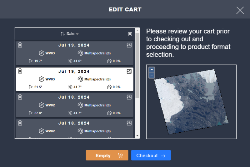
4.2 About checkout
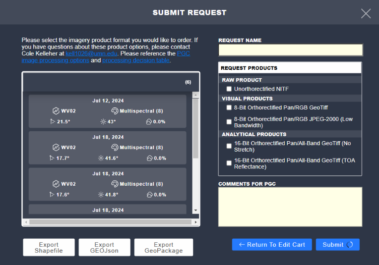
After users select the data for ordering and added to the Cart, users are ready to select a data product. Data products consist of processing operations applied to the selected data to enable analysis or mapping purposes.
Users are encouraged to reference the following guides for additional information to support product decisions:
There are 5 standardized product options categorized into 3 application types that determine the output format for the entire cart. If users require multiple formats for the same selected imagery, users must submit separate orders.
Raw Product
Unorthorectified NITF
Visual Products
8-Bit Orthorectified Pan/RGB GeoTiff
8-Bit Orthorectified Pan/RGB JPEG-2000 (Low Bandwidth)
Analytical Products
16-Bit Orthorectified Pan/All-Band GeoTiff (No Stretch)
16-Bit Orthorectified Pan/All-Band GeoTiff (Top of Atmosphere, TOA, Reflectance)
If different processing not readily available in FRIDGE are needed, users can add their needs within the comments section, or work with their listed PGC Point of Contact to determine the ideal processing parameters to receive the best product for the intended imagery application. This includes bulk data requests, as FRIDGE orders are limited to up to 200 images.
Also available at checkout are download links to vector extents of the selection exported in Shapefile, GEOJson, or GeoPackage formats.
4.3 About Data Delivery
After an imagery order is submitted, it is reviewed by the user’s PGC Point of Contact to ensure compliance with the EOCL license and scope of data request within the user’s selected federal award. Once approved, the order runs through PGC automated processing pipeline and uploaded to the FTP space associated with the user’s PGC User Account. Delivery times depend on multiple factors (order size, number in the queue, system maintenance, etc.) but are typically delivered within 1-3 days after submission. Users can reach out to their PGC Point of Contact for further order submission inquiries.
Find more information about suggested FTP clients in the PGC User Account guide
FAQ
- Do I need a PGC account to access FRIDGE?
- A PGC account is not required to access Public Data. However, a registered PGC User Account with verified NSF Office of Polar Programs (OPP) award information is required for Commercial Satellite Imagery access.
- How do I create an account to access FRIDGE?
- You must have an account with the Polar Geospatial Center in order to view the commercial high-resolution satellite imagery. If you would like an account please visit the Request New Account page.
- What does the EOCL License mean for commercial imagery I order from PGC?
- Commercial satellite imagery received via FRIDGE ordering is subject under the EOCL License. Commercial satellite imagery obtained under the EOCL License should only be used for a U.S. Government purpose (which includes federally funded awards) and should not be made publicly available without NGA/NRO approval.
- What does the EOCL License mean for high-resolution DEMs I access from FRIDGE?
- ArcticDEM and Reference Elevation Model of Antarctica (REMA)
DEMs created under the ArcticDEM and REMA project (with the exception of Alaska) will continue to be publicly available without restrictions and released on an annual basis. Alaska is the only region included in the previous ArcticDEM project domain that is no longer publicly releasable under the current agreement between NGA, NRO, and NSF. Please note: Custom DEMs you receive from PGC, outside of the FRIDGE platform, as well as DEMs you create yourself in support of your federally funded work have the same restrictions as commercial satellite imagery. Any DEMs created outside of the ArcticDEM and REMA project domains should not be made publicly available without NGA/NRO approval.
- What is not allowed when using commercial satellite imagery from FRIDGE?
- Prohibited Activities:
- Sharing or copying of imagery for purposes outside of the scope of the award
- Sharing of imagery with collaborators not funded under the award or collaborators at non-U.S. institutions
- Using the imagery after the term of an award has expired
- Posting the imagery to a public website without access controls, published paper, poster, etc.
- Sharing the imagery or imagery derived products with anyone planning to sell it or use it for commercial gain
- Why is the preview image slow to load?
- Although the application is optimized to display low resolution previews of selected data via the internet, slow internet connections can cause images to have some latency.
- Can I access real-time data?
- No, FRIDGE is not designed for real-time data access. PGC releases ArcticDEM and REMA data on an annual basis. If users with polar federal funding require more recent DEMs, they can contact their PGC Point of Contact for assistance. PGC’s imagery archive requires many steps (identify, order, ingest, catalog, etc.) before it becomes available in FRIDGE. There is typically a delay of about one month from acquisition time to when a given image will be available in FRIDGE. PGC can order more recent data for users on an ad hoc basis, contact your PGC Point of Contact for requests. See also MGP Xpress or G-EGD for the most recent Maxar imagery collected.
- What is the maximum resolution of the imagery?
- The resolution of an image depends on the imaging satellite it is collected from and spectral bands, but typically ranges from .3-.5 m in panchromatic and 1.2-2 m in multispectral. See the Maxar Satellite Constellation guide for details.
- Can I integrate FRIDGE data with my GIS software?
- Yes, you can download DEMs or satellite imagery for use in ArcGIS Pro or QGIS.
- What if I need a processing option that isn’t available in checkout (such as pansharpening, different file type, bulk amounts, etc.)?
- Users are encouraged to reach out to their PGC Point of Contact listed or simply add a comment to your order at acheckout noting what you need.
- How can I provide feedback, report a bug or issue?
- Please complete the feedback form provided in the settings menu on the FRIDGE page.
Feedback
PGC values user feedback to keep FRIDGE working, useful, and relevant to the user community needs. Please consider sharing any bugs/issues or feature requests by filling out the feedback form below.
Contact
We are all ears! For further assistance, please reach out to the PGC team at pgc-support@umn.edu for any questions or comments.